
The Dampier Peninsula, in Western Australia, boasts what is probably one the largest areas of dinosaur foot imprints anywhere in the world. And amazingly, many of the sites are still unmapped. But aerial tech is helping to spot and preserve these unique 140 million-year old rock relics. By Jeremy Torr.

A drone looks for dinosaur footprints. Courtesy Twitter.
Broome, Australia, August 2019. Take a trip to Broome in the far north of Western Australia, and the tourist blurbs will wax lyrical about the sea, the islands, the Pilbara mountains, whales and friendly dolphins. Not so many visitors know that just up the road on the Dampier Peninsula, evidence of massive dinosaurs is littered everywhere - but is in danger of disappearing before it can be documented.
Footprints left by giant sauropods, stegosaurs and ankylosaurs are still there, just as they were some 127 to 140 million years ago. As the massive dinos went about collecting their lunch in what was then an ancient sea coast, layers of what is called Broome Sandstone layered on top of them preserving the evidence in the shape of massive footprints (or tracks as the scientists call them) which is still being discovered.

That’s a very, very big footprint. Courtesy Steve Salisbury/Twitter.
"We've (found) several tracks up in that area that are about 1.7 metres long," said University of Queensland vertebrate palaeontologist and researcher Dr. Steve Salisbury. "They indicate animals that are probably around 5.3 to 5.5 metres to the hip, which is enormous. At first it would seem a footprint that size and an animal that big, is (not) scientifically possible," he added.
Some of the footprints are thought to come from theropod dinosaurs – the same family that spawned nightmare predators like Velociraptor and T.Rex, as they wandered along the muddy shoreline looking for a warm-blooded snack back in the Lower Cretaceous Epoch.
The sandy mud the animals walked through has been crushed down over the millennia, and is now the layered sandstone along 100km or so of the peninsula, known as the ‘Dinosaur Coast.’ There the spooky footprints remain, massive fossil evidence of the stalking giants. More than 15 distinct species of dinosaurs left their tracks in the mud, and they literally cover the area – but they are still being discovered, says Dr. Salisbury.
The glimpse of a 130-million-year-old world that these tracks provide is awe inspiring - Dr. Steve Salisbury
"These animals did exist. They were out there and we're seeing evidence of them having existed in the Kimberley 130 million years ago based on these tracks." Indeed, in the last eight years, researchers have identified thousands of dinosaur tracks at numerous tracksites in the rocks and on beaches from Roebuck Bay up towards Cape Leveque on the Dampier Peninsula.
To ensure that as many of the wandering dino footprints as possible are mapped in these remote and highly inaccessible areas, Dr. Salisbury and his team have turned to aerial surveying to help to map the area. An extra challenge is that some of the best-defined tracks were made by such massive beasts it is difficult for observers to get high enough above them to see a connected line of prints. Enter the Airborne Research Australia (ARA) drones and aerial mappers.
“Despite recent National Heritage listing, the majority of these tracksites are largely undocumented, (and) their full scientific significance is poorly understood,” says Airborne Research Australia, the high-tech mapping experts. “The aim of (this) project is to digitally map the dinosaur tracksites of the peninsula utilising high-resolution aerial photography with both manned and unmanned aircraft, airborne and hand-held LiDAR imaging, and digital photogrammetry,” they add.
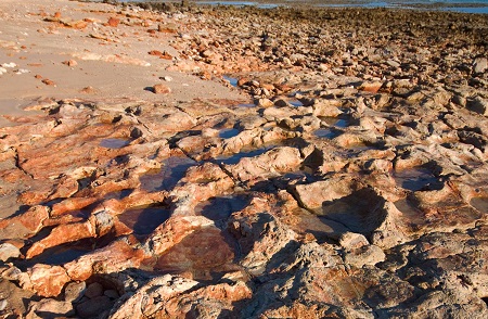
Dinosaur footprints? You can literally trip over them on the Dampier Peninsula. Courtesy Science News.
Using such fancy equipment as topographic LiDARs and a variety of RGB-cameras and videos they are mapping the whole coastline between Broome and Cape Leveque. ARA says it is confident this high-tech approach will allow researchers to construct high-resolution, 3D digital outcrop models of most of the tracksites, and help bring the 130 million-year-old landscapes back to life.
This mapping is needed, as the tracks, despite being part of the solid sandstone rock, are constantly being eroded by the large tides that lap the peninsula, and much evidence could be lost. "The coastline (here) is really dynamic and even things that we documented last year, a number of (tracks) have disappeared with the last cyclone season," said Dr Salisbury.
“These trackways are of international significance. The glimpse of a 130-million-year-old world that they provide is awe inspiring. But it is the linking of these track sites into the (aboriginal) songlines and associated indigenous cultures that adds a whole other dimension to their significance,” said Dr. Salisbury.